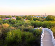
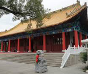
Chengde (Chinese: 承德; pinyin: Chéngdé), previously known as Jehol or Rehe (simplified Chinese: 热河; traditional Chinese: 熱河; pinyin: Rèhé), is a prefecture-level city in Hebei province, situated northeast of Beijing. It is best known as the site of the Mountain Resort, a vast imperial garden and palace formerly used by the Qing emperors as summer residence. The urban center had a population of approximately 450,000 as of 2009.
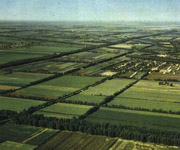
Langfang (Chinese: 廊坊; pinyin: Lángfáng), is a prefecture-level city of Hebei province, located approximately midway between Beijing and Tianjin. At the 2010 census, its population was 4,358,839 whom 868,066 lived in the built-up (or metro) area made of Guangyang and Anci districts. Its total area is around 6,417.28 km2 (2,477.73 sq mi). Langfang borders Baoding to the southwest, Cangzhou to the south (both prefecture-level cities of Hebei), Beijing to the north and Tianjin to the east. Sanhe City and Dachang Hui County are now conurbated with Beijing belonging to the same built-up area. It is the smallest prefecture-level city of Hebei by land area.

Qinhuangdao is a port city and prefecture-level city in northeastern Hebei province, People's Republic of China. It is about 300 km (190 mi) east of Beijing, on the Bohai Sea, the innermost gulf of the Yellow Sea. Its population during the 2010 census was 2,987,605, with 1,029,670 living in the built-up (or metro) area made of 3 urban districts.

Zhangjiakou, also known also by several other names, is a prefecture-level city in northwestern Hebei province, bordering Beijing to the southeast, Inner Mongolia to the north and west and Shanxi to the southwest. At the 2010 census, its population was 4,345,485 inhabitants on 36,861.56 square kilometres (14,232.33 sq mi). The built-up (or metro) area made of Qiaoxi, Qiaodong Districts and Wanquan County largely being conurbated had 838,978 inhabitants in 2010 on 1412.7 km2. Due to its position on several important transport arteries, it is a critical transport node for travel between Hebei and Inner Mongolia and connecting northwest China, Mongolia, and Beijing.
Baotou (Mongolian: ᠪᠤᠭᠤᠲᠤ ᠬᠣᠲᠠ Buɣutu qota; Chinese: 包头市) also known as Bugthot is the largest industrial city in the Inner Mongolia Autonomous Region of the People's Republic of China. Governed as a prefecture-level city, its built-up (or metro) area made up of 5 urban districts is home to 2,070,801 inhabitants with a total population of over 2.65 million accounting for counties under its jurisdiction. The city's Mongolian name means "place with deer", and an alternate name is "Lucheng" (鹿城; Lùchéng), meaning "Deer City".
Chifeng (Chinese: 赤峰市), also known as Ulanhad (Mongolian: ᠤᠯᠠᠭᠠᠨᠬᠠᠳᠠ ᠬᠣᠲᠠ (Улаанхад хот) Ulaɣanqada qota [ʊlaːnxad xɔt], "red cliff"), is a prefecture-level city in southeastern Inner Mongolia, People's Republic of China. It borders Xilin Gol League to the north and west, Tongliao to the northeast, Chaoyang (Liaoning) to the southeast, and Chengde (Hebei) to the south. The city has a total administrative area of 90,275 square kilometres (34,855 sq mi) and has a population of 4,341,245 inhabitants. As of the 2010 census, 1,094,970 of these residents reside within in the urban districts of Hongshan, Yuanbaoshan and Songshan. However, a large part of Songshan is still rural and Yuanbaoshan is a de facto separate town 27 kilometers away from the core district of Chifeng. The city was the administrative centre of the defunct Ju Ud League (昭乌达盟; ᠵᠤᠤ ᠤᠳᠠ ᠴᠢᠭᠤᠯᠭᠠᠨ).

Hohhot (Chinese: 呼和浩特; pinyin: Hūhéhàotè; Mongolian: ᠬᠥᠬᠡᠬᠣᠲᠠ Kökeqota; Khalkha: Хөх хот Khökh khot; also romanized as Huhehot or Huhhot), abbreviated Hushi(Chinese: 呼市; pinyin: Hūshì), formerly known as Kweisui (simplified Chinese: 归绥; traditional Chinese: 歸綏; pinyin: Gūisūi), is the capital of the Inner Mongolian Autonomous Region in North China, serving as the region's administrative, economic, and cultural centre. Its population was 2,866,615 inhabitants at the 2010 census whom 1,980,774 lived in the built-up (or metro) area made up of 4 urban districts. The name of the city in Mongolian means "Blue City"—Kuku-Khoto in Mongolian—although it is also wrongly referred to as the "Green City." The color blue in Mongol culture is associated with the sky, eternity and purity; in Chinese, the name can be translated as Qīng Chéng (Chinese: 青城), literally, "Blue/Green City."

Hulunbuir or Hūlúnbèi'ěr (Mongolian: ᠬᠥᠯᠥᠨ ᠪᠤᠶᠢᠷ ᠬᠣᠲᠠ Kölön Buyir qota; Chinese: 呼伦贝尔市) is a region that is governed as a prefecture-level city in northeastern Inner Mongolia, in the People's Republic of China. Its administrative center is located at Hailar District, its largest urban area. Major scenic features are the high steppes of the Hulun Buir grasslands, the Hulun and Buir lakes (the latter partially in Mongolia), and the Khingan range. Hulun Buir borders Russia to the north and west, Mongolia to the south and west, Heilongjiang province to the east and Hinggan League to the direct south. Hulunbuir is a linguistically diverse area: next to Mandarin Chinese, Mongolian dialects such as Khorchin and Buryat, the Mongolic language Dagur and some Tungusic languages are spoken there.
Tongliao (Mongolian: ᠲᠦᠩᠯᠢᠶᠣᠤ ᠬᠣᠲᠠ Tüŋliyou qota; Chinese: 通辽市) is a prefecture-level city in eastern Inner Mongolia, People's Republic of China. The area is 59,535 square kilometres (22,987 sq mi) and population is 3,139,153 (as of 2010); the city proper has 898,895 inhabitants (2010). The city was the administrative centre of the defunct Jirem League (哲里木盟; ᠵᠢᠷᠢᠮ ᠠᠶᠢᠮᠠᠭ). The original Mongolian name for Tongliao city proper (i.e. Horqin District) is Bayisingtu ('having buildings'), while the original name of the prefecture-level city is Jirem. The Mongolian dialect spoken in this area is Khorchin Mongolian.
Jinzhong (simplified Chinese: 晋中; traditional Chinese: 晉中; pinyin: Jìnzhōng) is a prefecture-level city with 3,249,425 inhabitants at the 2010 census in east central Shanxi province of the People's Republic of China. Before 1999, what is now Jinzhong was Jinzhong Prefecture, with its capital at the county-level city of Yuci (Chinese: 榆次; pinyin: Yúcì; Wade–Giles: Yu-tz'u). In 1999, Jinzhong Prefecture became Jinzhong Prefecture-level City, and Yuci County-level City became Yuci District (a county-level district). Yuci district is now part of Taiyuan built up area home to 3,848,151 inhabitants in 2010.
Benxi (Chinese: 本溪; pinyin: Běnxī) is a prefecture-level city located in the east of Liaoning province, People's Republic of China, south-southeast of Shenyang. Its population was 1,709,538 at the 2010 census whom 1,011,377 lived in the built-up area made of 3 urban districts (Pinshan, Xihu and Mingshan). It was founded as a metallurgical center in 1915. Benxi Iron and Steel Company ("Bengang") is the largest employer in the city, and used to be the fourth-largest steel company in China. The second-largest industry in Benxi is coal mining. Benxi has pollution problems due to steel production and coal mining. During the disaster of Air France flight AF447, Benxi Iron and Steel Company lost 5 employees, including the executive Chen Chiping who was the wife of Liaoning's provincial governor.
Dandong (simplified Chinese: 丹东; traditional Chinese: 丹東; pinyin: Dāndōng), previously known as Andong and Antung, is a prefecture-level city in southeastern-eastern Liaoning province, and is the largest Chinese border city, facing Sinuiju, North Korea across the Yalu River, which demarcates the Sino-Korean border. To the southwest of the city, the river flows into Korea Bay. Dandong has therefore had a dynamic history because of its strategic location for the northeast's rich natural resources and because of its convenient access to the ocean. It is designated as a major export production centre for the province, and is a port city connected by rail with Shenyang and Sinuiju. A significant amount of trade with North Korea flows through the city. The size of the administrative city (prefecture) is 14,981.4 square kilometres (5,784.4 sq mi); as of 2010, the built-up area made of 3 urban districts is 830 square kilometres (320 sq mi) in size and had 865,576 inhabitants. The administrative city covers around 2.45 million inhabitants as of 2010 census. The Hushan Great Wall, the far eastern end of the Great Wall of China, is located here.
Fushun (simplified Chinese: 抚顺; traditional Chinese: 撫順; pinyin: Fǔshùn, formerly romanised as Fouchouen, using French spelling) is a prefecture level city in Liaoning province, China, about 45 km (28 mi) east of Shenyang, with a population of 2,138,090 inhabitants (2010 census) and a total area of 11,271 km2 (4,352 sq mi), 713 km2 (275 sq mi) of which is the city proper. Situated on the Hun River ("muddy river"), it is one of the industrial and economic development hubs in Liaoning.
Liaoyang (simplified Chinese: 辽阳; traditional Chinese: 遼陽; pinyin: Liáoyáng) is a prefecture-level city of east-central Liaoning province, People's Republic of China, situated on the T'ai-tzu River and, together with Anshan, forms a metro area of 2,057,200 inhabitants in 2010. It is approximately one hour south of Shenyang, the provincial capital, by car. Liaoyang is home to Liaoning University's College of Foreign Studies and a number of vocational colleges. The city hosts a limited number of professional basketball and volleyball games in a modern sports facility.
Panjin (simplified Chinese: 盘锦; traditional Chinese: 盤錦; pinyin: Pánjǐn) is a prefecture-level city and a major oil production centre of Liaoning province, People's Republic of China, and is situated on the northern coast of Liaodong Bay of the Bohai Gulf. It borders Anshan to the northeast and east, Yingkou across the Liao River, as well as Jinzhou to the west and northwest. The city has an administrative area of 4,071 square kilometres (1,572 sq mi), is home to 1.39 million people all in the built-up area made of 2 urban districts plus Dawa and Panshan Counties being urbanized.
Baicheng (Chinese: 白城; pinyin: Báichéng; literally: "White City") is a prefecture-level city in the northwestern part of Jilin province, People's Republic of China, bordering Inner Mongolia to the north and west and Heilongjiang to the east and northeast. At the 2010 census, 2,033,058 people resided within its administrative area of 25,683 km2 (9,916 sq mi).
Tonghua (Chinese: 通化; pinyin: Tōnghuà) is an industrial city in the south of Jilin province, People's Republic of China. It borders North Korea to the south and southeast, Baishan to the east, Jilin City to the north, Liaoyuan to the northwest, and Liaoning province to the west and southwest. Administratively, it is a prefecture-level city with a total population of 2,325,242 living in an area of 15,195 square kilometres (5,867 sq mi). Urban population is 506,877. It is known as one of the five medicine production centres in China.
Yanji (Korean pronunciation: [jʌnɡil]), is the seat of the Yanbian Korean Autonomous Prefecture, in eastern Jilin province, People's Republic of China. Its population is approximately 400,000 of which a large section is ethnic Korean. Yanji is a busy hub of transport and trade between China and North Korea. Yanji and its environs were largely unpopulated until the 1800s when Qing dynasty rulers of China began to encourage migration there, as an effort to stem encroaching Russian expansion. Yanji is now part of the Yanbian Korean Autonomous Prefecture which is situated in the most easterly part of Jilin.[2] Yanji City is centrally located, surrounded by five other county-level cities and two rural counties (see map); it is the administrative seat of the prefecture.
Daqing (Chinese: 大庆; pinyin: Dàqìng; formerly spelled "Taching") (pronounced Da Tshing) is a prefecture-level city in the west of Heilongjiang province, People's Republic of China. The name literally means "Great Celebration". Daqing is known as the Oil Capital of China and has experienced a phenomenal boom since oil was discovered here in 1959. Its population was 2,904,532 at the 2010 census, of whom 1,415,268 lived in the built-up area (or metro) in 4 out of the total of 5 urban districts, i.e. (Sartu, Longfeng, Ranghulu and Honggang). Anda district of Suihua is also being conurbated next.

Jixi (Chinese: 鸡西; pinyin: Jīxī) is a city in southeastern Heilongjiang Province, People's Republic of China. At the 2010 census, 1,862,165 people resided within its administrative area of 22,488.47 square kilometres (8,682.85 sq mi) and 757,647 in its built-up (or metro) area made up of 3 out of 6 urban districts (including Jiguan, Hengshan and Chengzihe). Jixi is on the Muling River about 30 km (19 mi) from the border with Russia's Primorsky Krai and 120 km (75 mi) from Khanka Lake. The mayor of Jixi is Zhu Deyi (朱德义) since July 2009. The area is one of the important coal mining bases in China. A crater on asteroid 253 Mathilde was named after the city.
Qiqihar (simplified Chinese: 齐齐哈尔; traditional Chinese: 齊齊哈爾; pinyin: Qíqíhāěr; Manchu: Cicigar; formerly Tsitsihar) is one of the 13 Larger Municipalities in China, and the second largest city in the Heilongjiang province, People's Republic of China. The built-up (or metro) area made up of Longsha, Tiefeng and Jianhua districts had 979,517 inhabitants, while the total population of the prefecture-level city was 5,367,003 at the 2010 census. These are mainly Han Chinese, though the city is also home to thirty-four minorities including Manchu, Daur, and Mongolians.[2] Close to Qiqihar are numerous wetlands and the Zhalong Nature Reserve, famous in China for being home to numerous red-crowned cranes.
Huaibei (Chinese: 淮北; pinyin: Huáiběi) is a prefecture-level city in northern Anhui Province, People's Republic of China. It borders Suzhou to the east, Bengbu to the south, Bozhou to the west, and the province of Henan to the north. The population was 2,114,276 inhabitants at the 2010 census, all in the built-up area, comprising 3 urban districts and Suixi County largely being built.
Huainan (Chinese: 淮南; pinyin: Huáinán) is a prefecture-level city with 2,334,000 inhabitants in central Anhui Province, People’s Republic of China. It borders the provincial capital of Hefei to the south, Lu’an to the southwest, Fuyang to the west, Bozhou to the northwest, Bengbu to the northeast and Chuzhou to the east. Its built-up area is home to 1,938,212 inhabitants in 2010 spread out on 4 urban districts (Tianjia'an, Datong, Xiejiaji, Bagongshan and 1 county Fengtai) nowadays in agglomeration.

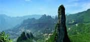
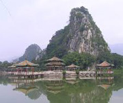
Huangshan (simplified Chinese: 黄山; traditional Chinese: 黃山; pinyin: Huángshān; literally: "Yellow Mountains"), is a mountain range in southern Anhui province in eastern China. The range is composed of material that was uplifted from an ancient sea during the Mesozoic era, 100 million years ago. The mountains themselves were carved by glaciers during the Quaternary. Vegetation on the range is thickest below 1,100 meters (3,600 ft), with trees growing up to the treeline at 1,800 meters (5,900 ft). The area is well known for its scenery, sunsets, peculiarly shaped granite peaks, Huangshan Pine trees, hot springs, winter snow, and views of the clouds from above. Huangshan is a frequent subject of traditional Chinese paintings and literature, as well as modern photography. It is a UNESCO World Heritage Site, and one of China's major tourist destinations. Huangshan is also the famous place for Chinese high quality teas, such as Huangshan Maofeng, Keemun Black and Blooming Tea.
Ma'anshan (simplified Chinese: 马鞍山; traditional Chinese: 馬鞍山; pinyin: Mǎ'ānshān), also written as Maanshan, is a prefecture-level city in the eastern part of Anhui province in Eastern China. An industrial city stretching across the Yangtze River, Ma'anshan borders Hefei to the west, Wuhu to the southwest, and Nanjing to the east. It is a core city of the Nanjing Metropolitan Circle. As of the 2010 census, Maanshan was home to 2,202,899 inhabitants whom 1,366,302 lived in the built-up area made of 3 urban districts and Dangtu County largely being urbanized. After the August 2011 administrative re-regionalization of Anhui Province, its population rose to 2.20 million, as 2 additional counties were placed under its administration (He and Hanshan).
Dongying (simplified Chinese: 东营; traditional Chinese: 東營; pinyin: Dōngyíng), a prefecture-level city, lies on the northern (Bohai Sea) coast of Shandong province, People's Republic of China. At the 2010 census, 2,035,338 people resided within its administrative area of 7,923.26 km2 (3,059.19 sq mi) and 998,968 in the built-up area made up of Dongying district and Kenli County largely being urbanized. Dongying is home to the Shengli Oilfield, which is, after Daqing (Heilongjiang), the second largest oilfield nationally.

Jining (simplified Chinese: 济宁; traditional Chinese: 濟寧; pinyin: Jǐníng) is a prefecture-level city in southwestern Shandong province. It borders Heze to the southwest, Zaozhuang to the southeast, Tai'an to the northeast, and the provinces of Henan and Jiangsu to the northwest and south respectively. Jining, which is located right to the north of the Lake Nanyang (Chinese: 南阳湖; pinyin: Nányáng Hú), is today the northernmost city reachable by navigation on the Grand Canal of China. Its population was 8,081,905 at the 2010 census, of whom 1,241,012 lived in the built-up (or metro) area made up of Rencheng urban district on 884 km2 (341 sq mi), Yanzhou district not being totally conurbated yet.

Liaocheng (Chinese: 聊城; pinyin: Liáochéng), also known as the Water City, is a prefecture-level city in western Shandong province, People's Republic of China. It borders the provincial capital of Jinan to the southeast, Dezhou to the northeast, Tai'an to the south, and the provinces of Hebei and Henan to the west. The Grand Canal flows through the city center. Its population was 5,789,863 at the 2010 census whom 1,229,768 lived in the built-up area made up of Donchangfu district, even though large parts remain rural. During the Song dynasty, the area of present-day Liaocheng included the prefectures of Bozhou (博州) and Jizhou (濟州). In 2007, the city is named China's top ten livable cities by Chinese Cities Brand Value Report, which was released at 2007 Beijing Summit of China Cities Forum.
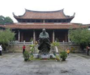
Qufu (Chinese: 曲阜; pinyin: Qūfù; Wade–Giles: Ch'ü1-fu4) is a city in the south-west of Shandong province, People's Republic of China. It is located at 35° 36′ northern latitude and 117° 02′ east, about 130 kilometres (81 mi) south of the provincial capital Jinan and 45 kilometres (28 mi) northeast of the prefecture seat at Jining. Qufu has an urban population of about 60,000, the entire administrative region has about 650,000 inhabitants. Qufu is the hometown of Confucius, who is traditionally believed to have been born at nearby Mount Ni. The city contains numerous historic palaces, temples and cemeteries. The three most famous cultural sites of the city, collectively known as San Kong (三孔), i.e. "The Three Confucian [sites]", are the Temple of Confucius (Chinese: 孔庙; pinyin: Kǒngmiào), the Cemetery of Confucius (Chinese: 孔林; pinyin: Kǒnglín), and the Kong Family Mansion (Chinese: 孔府; pinyin: Kǒngfǔ). Together, these three sites have been listed as a UNESCO World Heritage Site since 1994.
Weihai (Chinese: 威海; pinyin: Wēihǎi; English: Port Edward) is a city in eastern Shandong province, People's Republic of China. It is the easternmost prefecture-level city of the province and a major seaport. Weihai borders Yantai to the west and the Yellow Sea to the east. Weihai's population is 2,804,800 at the 2010 census. Of those, 591,982 live in the built up area (Huancui urban district). Rongcheng, a county level city within Weihai, has a built up area with 1,006,795 inhabitants. The minor planet 207931 Weihai is named after this city. Between 1898 and 1930, the city was part of the British leased territory known as Weihaiwei or the Weihai Garrison (traditional Chinese: 威海衛; simplified Chinese: 威海卫; pinyin: Wēihǎi Wèi), and also between 1898 and 1930 the city itself was known as Port Edward and served as the capital of Weihaiwei.
Zaozhuang (simplified Chinese: 枣庄; traditional Chinese: 棗莊; pinyin: Zǎozhuāng) is a prefecture-level city in the south of Shandong province, People's Republic of China. The second smallest prefecture-level city in the province, it borders Jining to the west and north, Linyi to the east, and the province of Jiangsu to the south. Its population is 3,729,140 at the 2010 census whom 899,753 in the built-up area made of Shizhong and Yicheng districts.
Lin'an City (Chinese: 临安市; Pinyin: Lín'ān Shì) is a county-level city in Hangzhou, Zhejiang Province of China. It is located in northwestern Zhejiang. Lin'an City has an area of 3124 square kilometers, and a population of 520,000 in 2002. The postal code is 311300, and the phone code 0571. The city government is located at 398 Yijin Street. The city is rich in natural resources, abundant in rainfall, and has a warm climate. All of these factors work together allowing the city to be covered with 71.3% forest. Such an ecological environment breeds more than 4,700 biological species. Mountains, lakes, forest, hot springs, caves, and other ancient remains are everywhere.

Changzhou (Chinese: 常州) is a prefecture-level city in southern Jiangsu province of China. It was previously known as Yanling, Lanling, Jinling, and Wujin. Located on the southern bank of the Yangtze River, Changzhou borders the provincial capital of Nanjing to the west, Zhenjiang to the northwest, Wuxi to the east, and the province of Zhejiang to the south. The city is situated in the affluent Yangtze Delta region of China. Its total population was 4,592,431 inhabitants at the 2010 census whom 3,290,918 lived in the built-up area made up of 5 urban districts. The agglomeration is now part of Shangai-Suzhou-Wuxi built-up area which has now more than 36,000,000 inhabitants, only second in China after Pearl River built-up area.
Huai'an (Chinese: 淮安; pinyin: Huái'ān), formerly called Huaiyin (simplified Chinese: 淮阴; traditional Chinese: 淮陰; pinyin: Huáiyīn) until 2001, is a prefecture-level city in central Jiangsu province of Eastern China. It borders Lianyungang, Suqian to the north, Yancheng to the northeast, Yangzhou to the southeast, and Chuzhou (Anhui) to the southwest. As of the 2010 census the municipality had 4,799,889 inhabitants, of whom 2,494,013 lived in the four urban districts.
Lianyungang (simplified Chinese: 连云港; traditional Chinese: 連雲港; pinyin: Liányúngǎng) is a prefecture-level city in northeastern Jiangsu province, People's Republic of China. It borders Yancheng to its southeast, Huai'an and Suqian to its south, Xuzhou to its southwest, and the province of Shandong to its north. Its name derives from Lian Island (formally Dongxilian Island) the largest island in Jiangsu Province which lies off its coastline, and Yuntai Mountain, the highest peak in Jiangsu Province, a few miles from its town center, and the fact that it is a port. Lianyungang (as Yuntai Mountain) was known in the West as Haichow (Wade–Giles romanization). This was one of the four original ports opened up for foreign trade in the 1680s by the Qing Dynasty Government. The others were Ningbo, Xiamen and Guangzhou.

Yancheng (Chinese: 盐城; pinyin: Yánchéng) is a prefecture-level city in northeastern Jiangsu province, People's Republic of China. The city with the largest jurisdiction area in Jiangsu, Yancheng borders Lianyungang to the north, Huai'an to the west, Yangzhou and Taizhou to the southwest, Nantong to the south, and looks out to the Yellow Sea to the east. Yancheng, literally "Salt City", is named after the salt harvest fields that surround the city. According to historical records,[which?] collection and production of sea salt in the region began as early as 119 BC during the Western Han Dynasty, when the settlement on the current location of Yancheng was named Yandu County (鹽都縣). According to the 2010 Census, Yancheng has a registered population of 8,203,728 — with 7,260,240 permanent residents. Its built up area made of Tinghu and Yandu Districts, was home to 1,615,717 inhabitants in 2010.
Dengfeng (Chinese: 登封; pinyin: Dēngfēng; Postal map spelling: Tengfeng) is a county-level city in Zhengzhou, Henan Province, China. In ancient times, it was known as Yangcheng (simplified Chinese: 阳城; traditional Chinese: 陽城; pinyin: Yángchéng). Dengfeng has an area of 1220 square kilometers and a population of 630,000. Dengfeng is located at the foot of the Mount Song, one of the most sacred mountains in China. The city is one of the most renowned spiritual centres of China, home to various religious institutions and temples, such as the Taoist Zhongyue Temple, the Buddhist Shaolin Temple, as well as the Confucian Songyang Academy, hence its poetic expression derived from Chinese literature as the spiritual "centre of heaven and earth".
Luoyang (Chinese: 洛阳; pinyin: Luòyáng;; IPA: [lwɔ̂jɑ̌ŋ]) is a prefecture-level city in western Henan province of Central China. It borders the provincial capital of Zhengzhou to the east, Pingdingshan to the southeast, Nanyang to the south, Sanmenxia to the west, Jiyuan to the north, and Jiaozuo to the northeast. As of the final 2010 census, Luoyang had a population of 6,549,941 inhabitants with 1,857,003 people living in the built-up (or metro) area made of city's five urban districts, all of which except the Jili District not urbanized yet. Situated on the central plain of China, Luoyang is one of the cradles of Chinese civilization, and is one of the Four Great Ancient Capitals of China.
Xinxiang (simplified Chinese: 新乡; traditional Chinese: 新鄉; pinyin: Xīnxiāng; Postal map spelling: Sinsiang) is a prefecture-level city in northern Henan province, People's Republic of China. It borders the provincial capital of Zhengzhou to its southwest, Kaifeng to its southeast, Hebi and Anyang to its north, Jiaozuo to its west, and the provinces of Shanxi and Shandong to its northwest and east respectively. Its population is 5,707,801 at the 2010 census of whom 902,731 are in the built-up area made of 3 out of 4 urban districts (Weibin, Hongqi and Muye). As the city is expanding very quickly, in a few years, Huixian and Weihui cities as well as Fengquan district and Xinxiang county will be added to the built-up area.
Enshi (Chinese: 恩施; pinyin: Ēnshī) is a county-level city in and the seat of Enshi Tujia and Miao Autonomous Prefecture, in western Hubei province, People's Republic of China. The prefecture's legislature, executive and judiciary are seated here, as well as its CPC and Public Security bureau. The entire county-level city of Enshi has an area of 3,967 square kilometres (1,532 sq mi) and a population of 780,000.
Huanggang City (simplified Chinese: 黃冈; traditional Chinese: 黃岡; pinyin: Huánggāng) is a major municipality (also known as a Prefecture) in eastern Hubei province, People's Republic of China. It is situated to the north of the middle reaches of the Yangtze River and is bounded in the north by the Dabie Shan mountain range. Seven counties fall under its jurisdiction (Tuanfeng, Hong'an, Xishui, Qichun, Huangmei, Luotian, and Yingshan) plus two county-level cities (Wuxue and Macheng), as well as two direct administrative divisions (Huangzhou and Longganghu). The city's administrative area covers 17,446.63 square kilometres (6,736.18 sq mi) and the total population was 6,162,069 as of the 2010 census, only 366,769 of whom resided in the urban area. The Ezhou - Huanggang built-up (or metro) area was home to 1,035,496 inhabitants comprising (Echeng district and Huangzhou district of Huanggang prefecture). In 2007, the city is named China's top ten livable cities by Chinese Cities Brand Value Report, which was released at 2007 Beijing Summit of China Cities Forum.
Jingzhou (Chinese: 荆州) is a prefecture-level city in southern Hubei, People's Republic of China, located on the banks of the Yangtze River. As of the 2010 census, its total population was 5,691,707, 1,154,086 of whom resided in the built-up (or metro) area comprising the two urban districts. Jingzhou's central urban area has grown out of a city historically known as Shashi; this name is preserved in the name of Shashi District, which includes the city's historical center, as well as in the names of a number of local facilities, such as Shashi Airport and a railway freight station.
Shiyan (Chinese: 十堰; pinyin: Shíyàn) is a prefecture-level city in northwestern Hubei province, People's Republic of China, bordering Henan to the northeast, Chongqing to the southwest, and Shaanxi to the north and west. At the 2010 census, its population was 3,340,841 whom 767,920 lived in the built-up (or metro) area ade of Maojian and Zhangwan urban districts on 1,193 km2. In 2007, the city was named China's top ten livable cities by Chinese Cities Brand Value Report, which was released at 2007 Beijing Summit of China Cities Forum.
Xianning (simplified Chinese: 咸宁; traditional Chinese: 咸寧; pinyin: Xiánníng) is a prefecture-level city in southeastern Hubei province, People's Republic of China, bordering Jiangxi to the southeast and Hunan to the southwest. It is known as the "City of Osmanthus".
Xiangyang (simplified Chinese: 襄阳; traditional Chinese: 襄陽; pinyin: Xiāngyáng) is a prefecture-level city in northwestern Hubei province, People's Republic of China. It was formed from two ancient cities, Xiangyang and Fancheng. It was known as Xiangfan (Chinese: 襄樊; pinyin: Xiāngfán) until December 2, 2010.[2] Xiangyang is divided by the Han River, which runs through its heart and divides the city north-south. The city itself is an incorporation of two once separate, ancient cities: Fancheng and Xiangzhou. What remains of old Xianyang is located south of the Han River and contains one of the oldest still-intact city walls in China while Fancheng was located to the north of the Han River. Both cities served prominent historical roles in both the Ancient and Pre-Modern Periods of Chinese history. Today, the city is, after the capital Wuhan, the second largest in the province, located about halfway between Wuhan and Xi'an. It is considered one of the third tier cities in China and has been a target of government and private investment as the country seeks to urbanize and develop the interior provinces. Its built-up area made up of 3 urban districts had 2,199,689 inhabitants at the 2010 census while the whole municipality contained approximately 5,500,307 people.
Changde (Chinese: 常德; pinyin: Chángdé) is a prefecture-level city in the northwest of Hunan province, People's Republic of China, with a population of 5,717,218 as of the 2010 census, of which 1,232,182 reside in the urban districts of Dingcheng and Wuling. In addition to the urban districts, Changde also administers the county-level city of Jinshi and six counties. Changde is adjacent to Dongting Lake to the east, the city of Yiyang to the south, Wuling and Xuefeng Mountains to the west, and Hubei province to the north. The area has been inhabited by humans since around 8,000 years ago. In that time, the city has changed names several times, but it has been known as Changde since the twelfth century. The city is well known for the Battle of Changde during the Second Sino-Japanese War (1937–45) and the atrocities committed then by the Imperial Japanese Army.
Chenzhou (Chinese: 郴州; pinyin: Chēnzhōu) is a city located in the south of Hunan province, People's Republic of China. Its administrative area covers 19,317 square kilometres (7,458 sq mi), 9.2% of the provincial area, and its total population reached 4,559,600 in 2001, 26% of them living in urban areas, 74% of them live in rural areas.

Hengyang (simplified Chinese: 衡阳; traditional Chinese: 衡陽; pinyin: Héngyáng) is the second largest city of Hunan Province, People's Republic of China. It straddles the Xiang River about 160 km (99 mi) south of the provincial capital of Changsha.
Huaihua lies is in the mountainous west of Hunan, south-east of Zhangjiajie National Forest Park, and shares the same mountain belt. The area's rural poverty is a continuing problem. Railroads provide the main transportation in the region, although an airport was opened in 2004. Huaihua is home to the Second Artillery Corps Base 55, which is charged with maintaining ICBMs. The nuclear assets at Huaihua are intended for small-scale nuclear conflicts (with a limited, but nuclear, exchange), as well as the ability to strike Guam, one of only two B-2 bases.
Jishou (Chinese: 吉首; pinyin: Jíshǒu) is a county-level city and the seat of Xiangxi Tujia and Miao Autonomous Prefecture, Hunan province, China. Jishou has a history of more than 2,000 years dating back to the Qin dynasty. In those days, it was affiliated with Qianzhong Prefecture (黔中郡). During the Song dynasty, a town government was established in a stockaded village, Zhenxi (镇溪寨; 鎮溪寨), which in the Ming dynasty became the Zhenxi soldiers and civilians battalion (镇溪军民千户所; 鎮溪軍民千戶所). Qianzhou Prefecture (乾州厅) was created during the Qing dynasty. During the Republic of China era it was known as Qian County (乾县; 乾縣) In 1953 the area was renamed Jishou county, with two adjacent cities, Jishou and Qianzhou. In 1982 Jishou city became the capital of Xiangxi Tujia and Miao Autonomous Prefecture. The city of Qianzhou (乾城) now lies just south of Jishou city.
Xiangtan (Chinese: 湘潭; pinyin: Xiāngtán; Wade–Giles: Hsiang-tan) is a prefecture-level city in Hunan province, China, located on the lower reaches of Xiang River. The hometowns of several founding leaders of the Chinese Communist Party, including Mao Zedong, Liu Shaoqi, and Peng Dehuai, are in the Xiangtan prefecture, as well as the hometowns of Qing dynasty painter Qi Baishi and scholar-general Zeng Guofan. As of 2010, it had 2,748,552 inhabitants, of whom 1,779,960 lived in the built-up area (2 urban districts plus Xiangtan county). Together with the four adjoining urban districts of Zhuzhou, its built-up area is home to 2,586,948 inhabitants. In 2007, the city is named China's top ten livable cities by Chinese Cities Brand Value Report, which was released at 2007 Beijing Summit of China Cities Forum.
Yiyang (simplified Chinese: 益阳; traditional Chinese: 益陽; pinyin: Yìyáng) is a prefecture-level city at the Zi River in Hunan province, People's Republic of China, straddling Lake Dongting and bordering Hubei to the north. According to the 2010 Census, Yiyang has a population of 4,313,084 inhabitants residing in an area of 12,144 km2 (4,689 sq mi). The previous census was in 2000 when it was recorded there were 4,309,143 inhabitants.
Yueyang (simplified Chinese: 岳阳; traditional Chinese: 岳陽; pinyin: Yuèyáng) is a prefecture-level city at the northeastern corner of Hunan province, People's Republic of China, on the southern shores of Dongting Lake. Yueyang has an administrative area of 14,896 km2 (5,751 sq mi) and the city proper, 304 km2 (117 sq mi). The population was 5,477,911 at the 2010 census whom 991,465 lived in the built-up (or metro) area made up of Yueyanglou District and Yunxi District. The city's most famous attraction is the Yueyang Tower.
Zhuzhou (Chinese: 株洲; pinyin: Zhūzhōu), formerly Jianning, is a prefecture-level city of Hunan Province, People's Republic of China, a little to the southeast of Changsha and bordering Jiangxi to the east. It is part of the "ChangZhuTan Golden Triangle" (comprising the cities of Changsha, Zhuzhou and Xiangtan). The city has jurisdiction over 5 counties (Yanling, Chaling, Youxian, Liling, Zhuzhou) and four districts (Hetang, Lusong, Shifeng and Tianyuan, a high-tech industrial development zone), and covers an area of 11,420 km2 (4,410 sq mi). It had 3,855,609 inhabitants as of the 2010 census, of whom 806,988 lived in the built-up area (4 urban districts). With areas adjoining Zhuzhou due to be agglomerated in a few years' time, the joint built-up area will be home to 2,586,948 inhabitants. Zhuzhou is located in a subtropical monsoon climate zone and with its abundant mineral and organic resources has one of the highest agricultural yields in Hunan Province.
Ji'an (Chinese: 吉安; pinyin: Jí'ān) is a prefecture-level city in Jiangxi province, People's Republic of China, bordering Hunan to the west. It has an area of 25,219 km2 (9,737 sq mi) and as of the 2010 census, had a population of 4,810,339, of whom 538,699 live in the built-up (or metro) area made of 2 urban districts. The local speech is a variety of Gan Chinese. The former deputy governor of the People's Bank of China, Xiao Gang, is from here. This city is also the home of Jinggangshan University.

Jingdezhen, (or the Town of Jingde), is a prefecture-level city, previously a town, in northeastern Jiangxi province, People's Republic of China, with a total population of 1,554,000 (2007), bordering Anhui to the north. It is known as the "Porcelain Capital" because it has been producing quality pottery for 1700 years. The city has a well-documented history that stretches back over 2000 years.
Jiujiang (Chinese: 九江; pinyin: Jiǔjiāng), formerly transliterated Kiukiang or Kew Keang, is a prefecture-level city located on the southern shores of the Yangtze River in northwest Jiangxi Province, People's Republic of China. It is the second-largest prefecture-level city in Jiangxi province, after the provincial capital Nanchang. Jiujiang literally means "nine rivers". Its population was 4,728,778 inhabitants at the 2010 census whom 704,986 in the built up area made of 2 urban districts (Xunyang and Lushan). In 2007, the city is named China's top ten livable cities by Chinese Cities Brand Value Report, which was released at 2007 Beijing Summit of China Cities Forum.

Shangrao (simplified Chinese: 上饶; traditional Chinese: 上饒; pinyin: Shàngráo) is a medium-sized prefecture-level city located in the northeast of Jiangxi province, People's Republic of China, bordering Anhui to the north, Zhejiang to the east, and Fujian to the south; the city's western reaches extend into Poyang Lake. According to the 2010 Census, Shangrao has a population of 6,579,714 inhabitants. Shangrao itself is at the very western edge of the Wu-speaking areas, while most of its associated counties speak Gan.
Yichun (Chinese: 宜春; pinyin: Yíchūn; Wade–Giles: I2-ch'un1; Postal map spelling: Ichun) is a mountainous prefecture-level city in western/northwestern Jiangxi province, People's Republic of China, bordering Hunan to the west. Yichun literally means "pleasant spring". It is located in the northwest of the province along a river surrounded by mountains. Yichun has a history of over 2,200 years. It was established in 201 BC during the Han Dynasty. Yichun has a profound Buddhist culture. "Can Lin Qing Gui", the monastic rules for Buddhists at the Buddhist temple, originated from Yichun. Yichun is also the birthplace of many famous literary figures, such as Tao Yuanming and Deng Gu, both of whom are great poets from ancient times. The transportation in Yichun is convenient. The State Highway 320, State Highway 105, the Shanghai-Ruijin Highway and the Ganyue Highway (the Jiangxi-Guangdong Highway) construct a comprehensive traffic network in the city. A large sports complex with two stadiums was built in the 1990s and draws teams for sports competitions from all across China. Agriculture is the main industry but other natural resource industries such as timber and mining are extremely important for the economy. Major mineral deposits include aluminum, tungsten, gold, zinc, and copper. Yichun is also a stop along the major railway running between Beijing and Nanchang, the capital of Jiangxi.
Longyan (simplified Chinese: 龙岩; traditional Chinese: 龍岩; pinyin: Lóngyán; Pe̍h-ōe-jī: Lêng-nâ or Liong-nâ; literally: "dragon rock"; Hakka language: Liùng-ngàm) is a prefecture-level city in southwestern Fujian province, People's Republic of China, bordering Guangdong to the south and Jiangxi to the west.

Quanzhou (formerly called Zayton/Chinchew, Chinese: 泉州; pinyin: Quánzhōu; Wade–Giles: Ch'üan2-chou1; Pe̍h-ōe-jī: Chôan-chiu) is the largest city of Fujian Province, People's Republic of China. It borders all other prefecture-level cities in Fujian but two (Ningde and Nanping) and faces the Taiwan Strait. In older English works, its name may appear as Chinchew, Chinchu, Choanchew, or Zayton, from Arabic. The prefecture-level city of Quanzhou has an area of 11,245 square kilometres (4,342 sq mi) and, as of the 2010 Census, a population of 8,128,530 inhabitants. Its extended metropolitan (built-up area) is home to 6,107,475 inhabitants, encompassing the Licheng, Fengze, and Luojiang urban districts, Jinjiang, Nan'an, and Shishi cities, Hui'an county, and the Quanzhou District for Taiwanese Investment. Quanzhou is now the 12th largest Chinese extended metropolitan area (as of 2010).
Sanming (Chinese: 三明; pinyin: Sānmíng; Foochow Romanized: Săng-mìng)) is a prefecture-level city in western Fujian province, People's Republic of China. It borders Nanping City to the north, Fuzhou City to the east, Quanzhou City to the southeast, Longyan City to the south, and the province of Jiangxi to the west. Sanming lies between Wuyi and Daiyun mountains.
Zhangzhou (Chinese: 漳州; pinyin: Zhāngzhōu; Wade–Giles: Chang1-chou1; Pe̍h-ōe-jī: Chiang-chiu; formerly Lung-ch'i) is a prefecture-level city in southern Fujian province, People's Republic of China. Located on the banks of the Jiulong River (Beixi), Zhangzhou borders the cities of Xiamen and Quanzhou to the northeast, Longyan to the northwest and the province of Guangdong (Shantou City) to the southwest. Zhangzhou is home to 4,809,983 inhabitants at the 2010 census whom those of Longwen and Xiacheng districts are considered as urban. These two districts, together with Longhai and Xiamen, form a metropolitan area that, as of 2010, is home to about 5 million inhabitants. In older English works, its name may appear as Chang-chow or Changchow and in Southeast Asian contexts it appears as Chiang-chew or Chiang Chew from the Hokkien name.
Foshan (Chinese: 佛山), is a prefecture-level city in central Guangdong province, People's Republic of China. The area under the city's jurisdiction is about 3,848.49 km2 (1,485.91 sq mi) and currently has a population of 7.2 million all urban. It's part of probably the most important built-up area in the world, the Pearl River Delta Mega City with more than 44,78 million inhabitants at the 2010 census spread on 9 municipalities (including Macao) and 17,573 km2. The native dialect is the Foshan variant of Cantonese, but many areas of Foshan are now occupied by Mandarin-speaking migrants.

Jiangmen (Chinese: 江门) is a prefecture-level city in Guangdong province in southern China with a population of about 4.45 million in 2010. The 3 urban districts are now part of Guangzhou – Shenzhen conurbation, probably the most important built-up area in the world called the Pearl River Delta Mega City with more than 44,78 million inhabitants at the 2010 census spread on 9 municipalities (including Macao) and 17,573 km2.

Meizhou is a prefecture-level city in eastern Guangdong province, People's Republic of China. It has an area of 15,864.51 km2 (6,125.32 sq mi), and a population of 4.33 million at the 2010 census. It comprises Meijiang District, Xingning City and six counties. Its built-up or metro area made up of 2 urban districts was home to 935,516 inhabitants at the 2010 census. Meizhou is honored with the titles of Hometown of Culture, Hometown of the Overseas Hakka Chinese and Hometown of Football.
Shaoguan (Chinese: 韶关), is a prefecture-level city in the north of Guangdong province, People's Republic of China, bordering Hunan to the northwest and Jiangxi to the northeast. It is home to the mummified remains of the sixth Zen Buddhist patriarch Huineng. Its built-up or metro area made up of Zhenjiang and Wujiang urban districts was home to 688,229 inhabitants at the 2010 census, Qujiang district not being conurbated yet.

Zhanjiang (Chinese: 湛江; pinyin: Zhànjiāng; French: Fort-Bayard), is a prefecture-level city at the southwestern end of Guangdong province, People's Republic of China, facing Hainan to the south. Its population was 6,994,832 inhabitants at the 2010 census. 1,611,868 live in the built-up area made of four urban districts: Chikan, Xiashan, Potou and Mazhang. In 2007, the city is named China's top ten livable cities by Chinese Cities Brand Value Report, which was released at 2007 Beijing Summit of China Cities Forum.
Zhàoqìng (Chinese: 肇庆) is a prefecture-level city of Guangdong province, People's Republic of China and is considered part of the Pearl River Delta region. It is well known for being a regional tourist hub, a medium-sized provincial "college town" as well as an up-and-coming manufacturing center. Residents from Guangzhou, Shenzhen and other nearby cities, as well as people from Hong Kong and Macau, are known to visit the city on weekend getaways and excursions. Its population was 3,918,467 at the 2010 census whom 1,232,462 lived in the built-up (or metro) area made of Duanzhou urban District and Gaoyao County largely being urbanized. Dinghu urban District is not yet conurbated. The main central city, excluding Seven Star Crags, is fairly flat, but thickly forested mountains lie just outside the city limits. Numerous rice paddies and aquaculture ponds are found on the outskirts of the city.
Zhuhai (Chinese: 珠海; pinyin: Zhūhǎi) is a prefecture-level city on the southern coast of Guangdong province in China. Located in the Pearl River Delta, Zhuhai borders Jiangmen to the northwest, Zhongshan to the north, and Macau to the south. Zhuhai was one of the original Special Economic Zones established in the 1980s. Zhuhai is also one of China's premier tourist destinations, being called the Chinese Riviera. The city's population is made up of mostly Mandarin speaking migrants. Its northern part made of Xiangzhou district is now part of the Guangzhou-Shenzhen built-up area, the biggest built-up area in the world with more than 44,478,513 inhabitants at the 2010 census encompassing the whole Shenzhen, Dongguan, Foshan, Zhongshan, Macao cities, main part of Guangzhou, and small parts of Jiangmen and Huizhou cities. According to the Chinese Academy of Social Sciences, Zhuhai is the most livable city in China.
Baise (Chinese: 百色; local pronunciation: paːk˧˥ ɬɐk˥) is the westernmost prefecture-level city of the Guangxi Zhuang Autonomous Region, People's Republic of China, bordering Vietnam as well as the provinces of Guizhou and Yunnan.
Liuzhou (柳州), is a prefecture-level city in north-central Guangxi Zhuang Autonomous Region, People's Republic of China. The prefecture's population was 3,758,700 in 2010, including 1,436,599 in the built-up area made of 4 urban districts. Its total area is 18,777 km2 (7,250 sq mi) and 667 km2 (258 sq mi) for built up area.
Qinzhou (simplified Chinese: 钦州; traditional Chinese: 欽州; pinyin: Qīnzhōu) is a prefecture-level city in Guangxi, People's Republic of China, lying on the Gulf of Tonkin and having an urban population of 944,000. The area originally belonged to Guangdong. The city was originally a county Qinxian (Chinese Postal Map Romanisation: Yamhsien). From the beginning of the present era, Qinzhou (Wade-Giles: K'in-chou] was for many centuries "the center of Chinese overland trade with Indo-China".
Wúzhōu (Chinese: 梧州; Jyutping: Ng⁴zau¹), other names include Wuchow (Chinese Postal Map Romanization), and Ngchow (historically romanised name), is a prefecture-level city in the east of Guangxi Zhuang Autonomous Region, People's Republic of China. Wuzhou is located in eastern Guangxi bordering Guangdong province. It is at the confluence of the Gui River and the Xun River where they form the Xi River; 85% of all water in Guangxi flows through Wuzhou. The total area of Wuzhou is 12,588 km2 (4,860 sq mi).
Dānzhōu (Chinese: 儋州) is a city in the northwest of the Chinese island province of Hainan. It is a county-level city administered directly by the province. Although called a "city", Danzhou refers to a large land area in Hainan - an area which was once a county. Within this area is the main city, Danzhou City.
Hǎikǒu (Chinese: 海口), is the capital and most populous city of Hainan province, People's Republic of China. It is situated on the northern coast of Hainan, by the mouth of the Nandu River. The northern part of the city is the district of Haidian Island, which is separated from the main part of Haikou by the Haidian River, a branch of the Nandu. Administratively, Haikou is a prefecture-level city, comprising four districts, and covering 2,280 square kilometres (880 sq mi). There are 2,046,189 inhabitants in the built up area all living within the 4 urban districts of the city. Haikou was originally a port city. Today, more than half of the island's total trade still goes through its ports. The city is home to Hainan University, which has its main campus on Haidian Island.
Mianyang (simplified Chinese: 绵阳; traditional Chinese: 綿陽; pinyin: Miányáng) is the second largest prefecture-level city of Sichuan province in Southwest China. Its population was 4,613,871 at the 2010 census covering an area of 20,267.46 square kilometres (7,825.31 sq mi) consisting of Jiangyou, a county-level city, six counties and two urban districts. Its built-up (or metro) area was home to 1,722,133 inhabitants including the city proper of Mianyang (two urban districts) and An County largely being conurbated as urbanisation sprawls. In 2006, Mianyang was ranked as China's third "most suitable city for living" by China Daily, after coastal cities Dalian and Xiamen.

 Immediate attention